Devotech Africa online Community now
available.
Join
the Devotech Online Community. Find, connect, and share with
people who love Civil Engineering as much as you do. If your product is not listed here, please let us know, and if it's
appropriate, we'll add
it.
Extend your AutoCAD Civil 3D with the following additional
modules:
|
Road Marking software for AutoCAD and
Civil 3D
Watch the demonstration
video
|
|
|
|
Devotech Professional Extension for Town Planning, Roads, Water, Storm water and
Sewer Design

Version 4.2 is
available!
This is
our biggest release to date and we are very proud of the functionality we are providing in this
release.This release has been developed on the wishes of our
users, and we believe that you will benefit greatly from the new
functionality.
We would like to thank all our users for all their positive
input and participation. Your contribution to the Devotech Professional Extension made AutoCAD
Civil 3D a localised solution that provides unmatched productivity to the South African Engineering
Industry.
To read more about what's in this
release click here.
|
Devotech Bridge Module
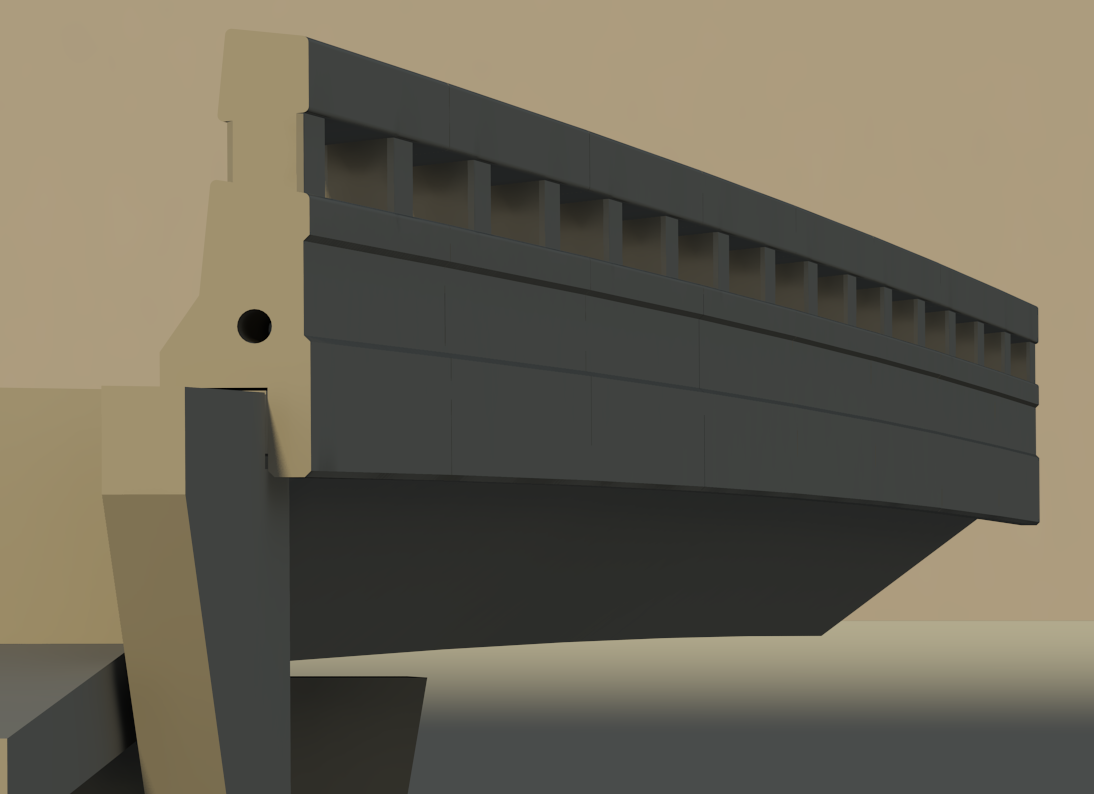
Devotech Africa has
developed a solution for modelling these unique concrete structures, to ensure a simplistic
approach, minimising modelling time, while ensuring increased accuracy of designs.
Devotech Africa uses a combination of AutoCAD Civil 3D, and Autodesk
Revit structures to deliver this solution.
Devotech Africa’s Bridge Modelling solution uses
a single model to derive all views, sections and elevations dynamically from the
model. This means that any change to the model, will
update all relevant sections, elevations and construction documentation dynamically.
Levels on the abutments, piers, decks, or any other component
are automatically calculated from the bridge model, since the model is geo-referenced and
modelled from the survey data available. Bridge
clearances can also be evaluated with ease. Normally,
this process would take an advanced user between two and three weeks, but with Devotech’s
Bridge Modelling, this task can be completed in two to four
days.
|
Ferrovia - Software for Railway
Design and Maintenance

Ferrovia
offers a large set of commands from basic to detailed level from survey data input to
plotting or 3D model creation. Ferrovia enables engineers to prepare professional drawings
and technical documentation with volume calculations and other data analysis including rail
track geometry calculation and data export to specialized rail track machinery. AutoCAD Civil
3D is the primery software platform for
Ferrovia.
Ferrovia
can be used for:
- Convensional rail track design
- Platform design with junctions and
switches
- Rail
track geometry calculations and direct data export to tamping
machinery
- Rail
track envelope clearance analysis in layout and cross
sections
- Industrial rail trach design and underground rail track
design
- Light
rail design in urban areas
|
|
Autopath vehicle swept path
analysis

Extension for swept path analysis and driving
simulation. It can be used to analyse intersections, roundabouts, narrow streets, garage
entrances, etc. or to check maneuverability and clearance.
Some feaures:
- Automatic driving simulation along the selected
Civil 3D alignment or polyline with the front or rear vehicle
axis;
- Intuitive manual driving simulation controlled by
the mouse;
- Graphical representation of the analysis results
with tyre paths, outer edge, coloured area and many more.
|
Autopath
continues...
Ease of
use
Autopath is so easy to use that no training should be required. User
are up and running in a matter of minutes.
Custom Vehicle
Library
Create custom vehicles with
an easy to use interface. Included in the product are vehicle libraries such as AASHTO and
others that consist of airplanes, trucks, trailers, cars. There is no extra cost for
additional vehicles.
Easy Drive
an
interactive method of defining the vehicle path. Besides an easy input this method includes
realistic simulation because it considers parameters such as vehicle speed, wheel turning speed and
the superelevation of the road.
Vertical
Clearances
is used to check a vehicles clearance for things such as parking garages, bridges and
more.
Affordable
Autopath is a fraction of the cost of similar software on the market. It was developed to offer
users a low cost solution with all the high end features.
|
Plateia
Plateia - traffic
module is dedicated to designing traffic signalisation, intersection geometry and swept path
analysis:
- - Contains complete swept path analysis - Autopath
- - Draw, edit and report traffic signs
- - design of pavement markings (zebras, longitudinal markings, ghost
islands)
- - design of splitter islands (teardrop,
triangular)
- - complete dynamic roundabout design - design and edit roundabout geometry,
road markings and traffic signs
- - curb return fillets
- - bus bays
|
Autodesk Infrastructure Design
Suite
Autodesk Infrastructure Design Suite offers a
comprehensive solution for planning, designing, building, and managing infrastructure projects at an
exceptional value.
AutoCAD® software provides powerful design and
documentation tools, extensive customization options, and native DWG™ support to take infrastructure projects
further.
AutoCAD® Map
3D software is a model-based infrastructure planning and
management application that provides broad access to CAD and GIS data, helping geospatial and planning
professionals make more informed design and management decisions.
AutoCAD® Civil 3D® software brings the power of BIM to
infrastructure projects to help civil engineering professionals stay coordinated, more easily and efficiently
explore design options, analyze project performance, and deliver consistent, higher-quality
documentation.
Autodesk® 3ds Max® Design software helps
you create near photorealistic renderings and animations to tell the story behind designs. Dynamically link
to civil data, validate designs, and better communicate project intent.
Autodesk® Navisworks® Simulate software
provides advanced tools for review and coordination of project information. Comprehensive 4D simulation and
animation capabilities enable better design insight and predictability. Real-time navigation combined with
review toolsets supports collaboration among the project team.
Autodesk® Navisworks® Manage software** is a
comprehensive review solution for analysis, simulation, and coordination of project information.
Multidisciplinary design data can be combined into a single integrated project model for interference
management and clash detection. Navisworks Manage helps design and construction professionals anticipate and
avoid potential problems before construction.
Autodesk® Storm and Sanitary Analysis software* is a comprehensive hydrology and hydraulic analysis
application for planning and designing urban drainage systems, highway drainage systems, storm sewers, and
sanitary sewers.
*Autodesk Storm and Sanitary Analysis is included with AutoCAD Map 3D 2012
and AutoCAD Civil 3D 2012.
**All of the capabilities of Autodesk Navisworks Simulate are included in Autodesk
Navisworks Manage.
Autodesk Infrastructure Design Suite helps you:
• Bring multiple types of data together into a single view to better
understand project impact and help inform design and management decisions.
• Gain greater insight into planning, design, and
construction with integrated analysis capabilities to better predict project outcomes.
• More easily accommodate design changes with synchronous
design and drafting.
• Create compelling renderings to help communicate design
intent and better understand projects in real-world surroundings.
• Help increase visibility into constructability, cost, and
schedules.
• Manage your infrastructure information more dependably with
intelligent industry models that help you maintain data quality standards.

|